Desert Hydrology Block Diagram
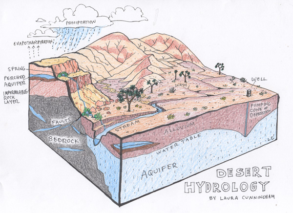
March 31, 2019 - This classic block diagram by a Basin and Range Watch co-founder is going viral on social media. Pen and ink with colored pencil, this illustrates basic generalized hydrology of aquifers and springs in the Mojave Desert of California, Nevada, and Arizona. We have commented on hundreds of environmental review documents over the past 10 years where poorly-sited large-scale solar projects (especially concentrated solar thermal technologies) have proposed groundwater pumping that over the years will cause cones of depression. Large gold and lithium mines will cause groundwater impacts as well. And bad projects such as the Cadiz water storage project would also similarly impact desert aquifers.
A large portion of that blue aquifer is actually "fossil water" -- water deposited tens of thousands of years ago during Ice Ages when conditions were much wetter in the Southwest deserts, and groundwater recharge was at a maximum.
Today groundwater recharge from rainfall is minimal, and we need to minimize pumping and groundwater depletion in our precious deserts.
This was meant as a simple illustration to educate kids on field trips to the desert from urban areas, organized by friends. But as one of our board members pointed out, simplifying science down to the kindergarten level can be highly benefifical to educating adults as well.