California Energy Commission Releases Environmental Review Documents
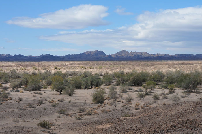
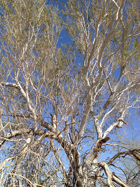
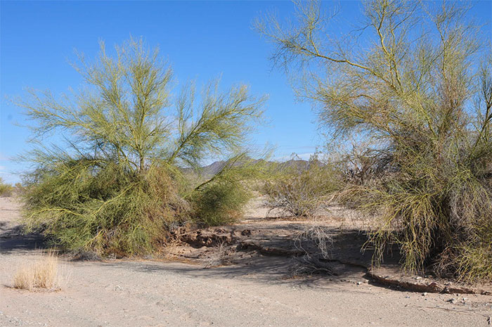
^Large wash at the southern end of the project site, looking towards the Palo Verde Mountains.
October 2, 2012 - Part A of the Preliminary Staff Assessment (PSA) was released on September 28, discussing the Rio Mesa Solar Electric Generating Facility. Evaluations include sections on Air Quality, Hazardous Materials Management, Noise and Vibration, Public Health, Socioeconomics, Water Supply, Soil and Surface Water, Traffic and Transportation, Transmission Line Safety and Nuisance, Visual Resources, Waste Management, Worker Safety and Fire Protection, Facility Design, Geology and Paleontology, Efficiency, Reliability, and Transmission System Engineering.
Part B includes Biological Resources, Cultural Resources, Land Use, and an engineering evaluation. We will be commenting on this shortly.
The PSA contains analyses similar to those normally contained in an Environmental
Impact Report (EIR) required by the California Environmental Quality Act (CEQA).
When considering a project for licensing, the Energy Commission is the lead state
Fossil Beds
Imagine a desert landscape with mammoths roaming, herds of wild horses, jackrabbits, and desert tortoises. Also grazing on grasses are giant tortoises as large or larger than the Galapagos tortoise. This was the scene in the Ice Age Colorado River corridor, prior to 10,000 years ago. Significant fossil discoveries have been made on the Rio Mesa site by surveyors, revealing a lost world that could have fossils beds rivaling those at the famous La Brea Tar Pits in Los Angeles. The Ice Age, known as the Pleistocene Epoch, lasted from 2 million years ago to 10,000 years ago.
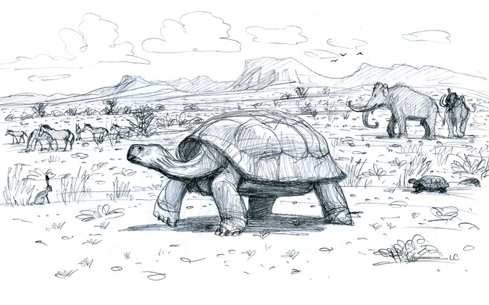
^Giant tortoise (Hesperotestudo sp.) in an Ice Age Colorado Desert landscape with Columbian mammoths (Mammuthus columbi) and horse (Equus sp.). A desert tortoise (Gopherus sp.) emerges from its burrow to a very different fauna than what exists today in the region, sharing the habitat only with jackrabbits (Lepus sp.) currently. Illustration Copyright Laura Cunningham.
These significant paleontological resources identified on the project site include many labeled "high sensitivity." The PSA states that "during the applicant’s initial paleontological field survey of the project site, a previously unrecognized, widely distributed paleosol (fossil soil), now known as the Palo Verde Mesa Paleosol, was discovered. To date, nearly 800 vertebrate fossils have been collected from the surface of the paleosol. In addition, the Chemehuevi formation equivalents and Late Pleistocene silts, sands and gravels are significant potential fossil bearing units identified on the site."
Most of the fossils apparently are found in deposits that represent past small shallow floodplain lakes. The location and abundance of the fossil beds is yet unstudied.
But heliostat foundation construction of predrilling and vibratory pedestal insertion could destroy all fossils encountered where installation takes place in the high sensitivity fossil bearing sediments. Predrilling involves rotating and boring a solid steel drill auger into the
ground. This construction method would crush or break any fossils that might be present.
Based on the presence of fossils within the Colorado River terrace deposits, they have
been assigned a date of middle to Late Pleistocene in age. The premier organization for vertebrate fossil study, Society of Vertebrate Paleontologists, states that a vertebrate fossil is considered scientifically important unless otherwise demonstrated, due to the rarity of such remains.
The Palo Verde Mesa paleosol has sediments laid down by the Ice Age Colorado River. Fossils found include tortoise bones and eggshells (21 %). Remains are those similar to the living desert tortoise (Gopherus) as well as the gigantic extinct Hesperotestudo. Also found were jackrabbit and cottontail fossils (both Lepus and Sylvilagus), a badger skull and mandibles (Taxidea), rodents, lizard, snake, bird bones, fragments of deer antler, probable bighorn sheep, mammoth ivory, and horse teeth (Equus). These fossils have been dated to approximately 13,700 years before present. Many of the fossils were in ancient animal-dug burrows. There are indications that this area was a desert refugium even during the cooler Pleistocene time. This paleosol will be impacted by construction grading and excavation, says the Energy Commission.
The Chemehuevi Formation includes finely bedded reddish mud, clay and silt visible on the lower parts of the bluffs of the Palo Verde Mesa, and are rare at the surface of the project
footprint. A few exposures thought to be Chemehuevi Formation equivalents were
encountered. They are probably present in the subsurface over much of the project site.
Earlier work on this formation in the region, such as in nearby Arizona, found fossils of turtle, snake, lizard, bird, ray-finned fish, and proboscidean tusk. These beds may be 41,000 to 102,000 thousand years old.
Staff told the applicant that a Supplemental Paleontological Resources Delineation Report must be submitted no later than December 3, 2012. In it should be maps and drawings of all facilities and ground disturbance. A monitoring and sampling plan should be made. If significant fossils are found, a plan should be given for how construction will be halted and resumed. Some fossils may be removed and inventoried for deposition into a museum. After construction is completed a report of finds shall be prepared, and this suffices as mitigation.
In our opinion this is an amazing fossil discovery and important to science. The California Energy Commission should withhold approval of the project until a thorough paleontological survey is completed in order to assess the nature of this fossiliferous region. We request a two year delay of this project in order to invite institutions to explore and document this find. We know of no other Pleistocene bed this extensive and diverse in the Mojave and Colorado Deserts with the exception of the Las Vegas Wash fossil beds in Clark County, Nevada -- an area dated to mid Pleistocene that also holds mammoth tusks; this area is being recommended by the Sierra Club, National Parks and Conservation Association, and other groups to be made into a National Monument. We feel that the Rio Mesa area may hold a similarly significant fossil bed or beds worthy of protection. Mitigation should include a visitor center for interpretation of this unique fossil landscape, and the applicant should be required to analyze alternative sites in order to avoid this rich zone. The prehistory of the ancient Colorado River may be told in the stories revealed by these fossil strata.
The Project
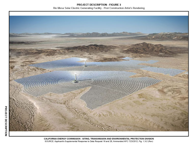
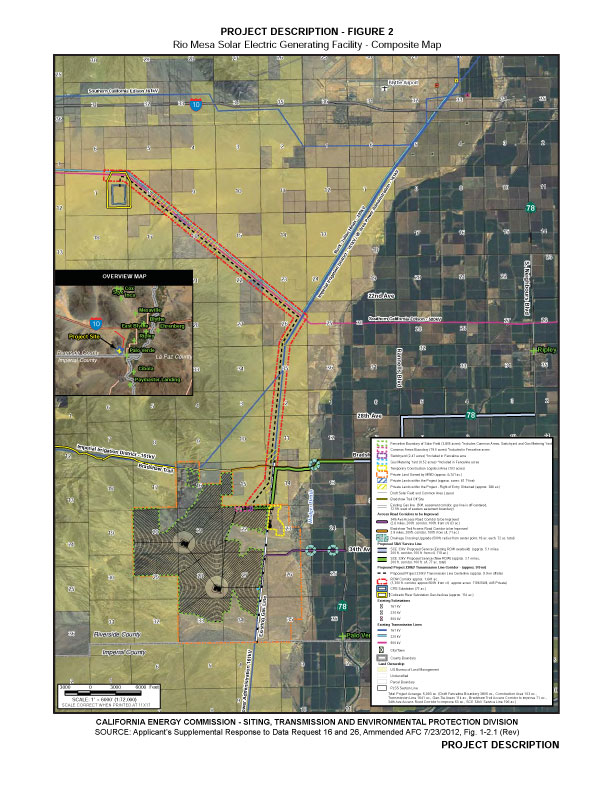
Rio Mesa SEGF would cover approximately 3,805 acres. This area would include the two proposed power plants, associated heliostat fields, and support facilities located within a common area. Off-site project components would include a temporary construction area, transmission line corridors, and access roads encompassing approximately 2,188 acres, for a total of approximately 5,993 acres of desert land.
Each solar plant would generate 250 megawatts (MW) (net), for a total net output of 500 MW and would use heliostats – large mirrors guided by a tracking system mounted on pylons – to focus the sun’s rays on a receiver located on top of a 750-foot-tall cement power tower near the center of each solar field. Each solar field would use
approximately 85,000 heliostats.
Natural gas would be burned in auxiliary boilers to assist in morning start up and late afternoon when solar energy is diminished.

Water Use
Each 250 MW plant would require up to 84.5 acre feet per year (afy) or total of 169 afy for the entire 500 MW project. This does not include approximately 4.3 afy for common area uses. Water would be pumped from the aquifer using on-site wells. The plant would use dry-cooling for most of the year, but small amounts of wet-cooling would be used when the air temperature went above 85 degrees F. We note that nearby Blythe, CA, had a high temperature of 106 F yesterday on October 1. Will wet cooling be needed for half the year? How much extra water will be requested?
The PSA says one Wet Surface Air Cooler (WSAC) system in each power block would have a water flow rate of 4,000 gallons per minute (gpm). Each WSAC system would operate no more than 2,000 hours per year. This minimum would be approximately 30 afy of groundwater use.
The drawdown impact at the proposed project pumping well, under estimated representative conditions, could be as high as 29 feet.
The PSA says: "The proposed project would pump up to 5,506 AF of groundwater over the three-year construction period and 25-year life of the project. There is concern that since
groundwater is in hydraulic connection with the Colorado River, project pumping may
capture groundwater that would otherwise contribute to the volume of water flow in the
river. The Colorado River is currently over-appropriated and any reduction in river flow
would result in a significant impact." (page 4.9-21)
The PSA states: "The Colorado River is managed and operated under numerous compacts, federal laws, court decisions and decrees, contracts, and regulatory guidelines collectively known as the 'Law of the River.' This collection of documents apportions the water and regulates
the use and management of the Colorado River among the seven basin states and
Mexico. According to the “Law of the River,” wells that draw water from the Colorado
River by underground pumping need an entitlement for the diversion of water from the
Colorado River. Consumptive use can occur through direct diversions of surface, as well as through withdrawal of water from the river by underground pumping." (page 4.9-31)
The water table at the project site is at or slightly above the accounting surface elevation as ruled by the Colorado River Commission, and so any withdrawal of groundwater by the project could have significant impacts to the Colorado River. Therefore the applicant will have to find mitigation measures to replace this same amount of water.
But there simply is not enough water in the Colorado River to meet human demand. The imbalance averages 3.6 million afy, or 12 times what Las Vegas is annually allocated as its share by the federal government, which is by law the river master. The river is massively over-allocated, and even more demands are planned for the upper Colorado River Basin: hydraulic fracturing of oil-shale and tar sands technology could need 800,000 afy or more of river-basin water in Wyoming, Utah and Colorado. If this oil-shale drilling occurs with accompanying water use, the annual imbalance would rise to 4.4 million afy, equivalent to California's entire yearly allocation. Any pumping by the applicant for a solar project using Colorado River water must be considered in this cumulative scenario (source: Colorado River water working group meeting hosted by National Resources Defense Council and .
The Energy Commission says the applicant must find water conservation projects to make up for removal of possible Colorado River water. These could include payment for irrigation improvements in the area, purchase of water rights within the Colorado River Basin to be held in
reserve in perpetuity, tamarisk eradication, purchase of water from the City of Needles
Water Bank, or other proposed mitigation methods. If it is determined that Colorado River water is being diverted by groundwater pumping, then the Municipal Water District (the owner of the Project site land) would have to purchase and replace this same amount from their non-Colorado River supplies and decrease their diversion of Colorado River water from Parker Dam.
The 5,506 acre feet of groundwater that would be pumped over the life of the proposed
project is small compared to the estimated 6,840,000 AF of water in storage in the Palo Verde Mesa aquifer, but adds yet more imbalance to the over-allocated Colorado River.
Well drawdown could lower the water table 10 feet in nearby Ironwood woodlands. Staff recommends that the applicant monitor stress and mortality in the trees.
Vegetation Cutting
The PSA says: "Other than areas required for access roads and drive zones, vegetation would be cut to a height of approximately 12 to 18 inches to allow clearance for heliostat function and, at the same time, leave the soil surface and root structures intact. Occasional trimming of the vegetation may be required during the operational phase of the project to control plant re-growth that could affect heliostat mirror movement." The applicant might as well grade the area flat, as chopping 25-foot tall Desert ironwood (Olneya tesota) trees with large woody trunks. This will be like clearcutting a forest. Cutting trees down to one foot stumps could kill most of them.
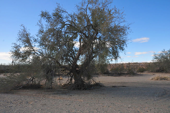
^Desert ironwood tree.
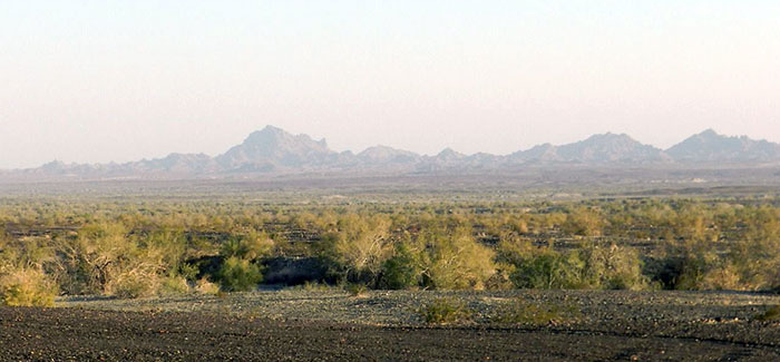
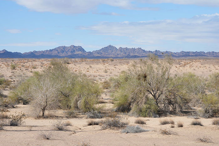
^Microphyll woodland on the project site as seen from the Bradshaw Trail looking southeast towards the Palo Verde Mountains.
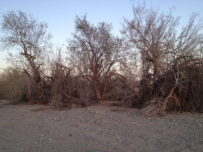
^Desert ironwoods along a small wash within the project site along a dirt road heading south from the Bradshaw Trail.
^Ironwood wash on the eastern edge of the project site.
^Palo verde trees near Bradshaw Trail.
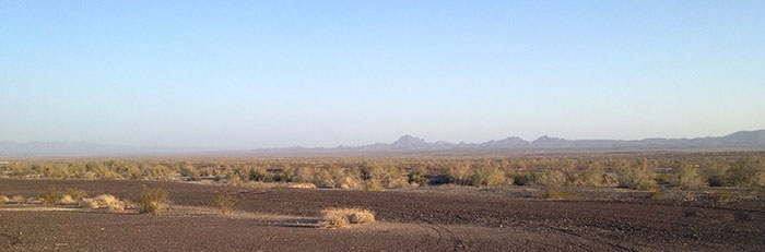
^Panorama looking south across the project area from the Mule Mountains towards the Palo Verde Mountains. Ironwood and Palo verde trees appear dense. Will this be clearcut?
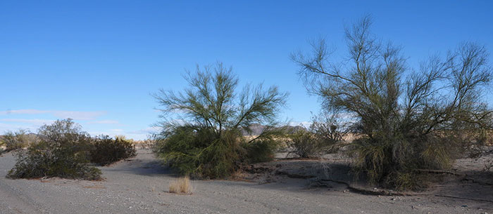
^Palo verdes in a wash on the project site in the southeast part.
Storm Drainage System
The site has large deep washes that channel flash floods across the Palo Verde Mesa. 29 ephemeral washes cross the project site, and three were designated as "Waters of the U.S." by the U.S. Army Corps of Engineers under Section 404 of the Clean Water Act. BrightSource proposes to keep the original grades and natural drainage features across
the majority of the project site. In limited areas, such as the power blocks, substation, heliostat assembly buildings and administrative areas, diversion channels, bypass channels, or swales to direct run-on flow from up-slope and run-off flow through and around each plant would be constructed. We question the efficacy of such storm water control systems after the destructive flood that wiped out a portion of the Genesis Solar Energy Project in an adjacent watershed.
The applicant has not provided a Storm Water Pollution Prevention Plan (SWPPP), or a Drainage Erosion and Sediment Control Plan (DESCP). We hope the public will be able to review these documents soon.
^Large wash on the southern margin of the project. many washes appear as if they carry large volumes of storm floods on occasion.
Comment Deadline
The Energy Commission should extend the comment deadline for the Rio Mesa Solar Energy Generating Facility. Like all CEC documents, this one is very long and very detailed. The CEC is only giving people 30 days to comment on the biological resources section of the PSA and this section is full of conflicts and unresolved issues. It is among the most complex of all the issues for this project. The CEC has a responsibility to allow a reasonable time frame for the public to review these projects. Several resources in the public domain will be adversely impacted by this project. It is very important that the CEC allocate enough time to solicit public review. The Bureau of Land Management reviews similar projects with a minimum of a 45 day comment period and a maximum of 90 days. This is a reasonable request for the Rio Mesa PSA. It is not reasonable to only give the public a 30 day review period. An additional 60 days should be given to comment.
Se also ReWire at KCET - http://www.kcet.org/news/rewire/solar/concentrating-solar/energy-commission-releases-preliminary-assessment-of-rio-mesa-solar.html
HOME.....Updates.....Site Visit